Mowbray Park
Area: 16.1 ha
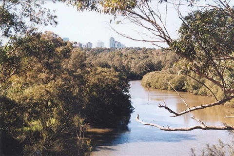
Mowbray Park is a long continuous area of remnant bushland located along the Lane Cove River in Lane Cove North. It is bounded by Chatswood Golf Course to the north east, almost reaching Swaines Creek and to the west by the Epping Road bridge.
The Gamaraygal people originally occupied the area. The Park contains a number of Aboriginal sites, including middens, shelters, artwork, axe grinding grooves and a campsite.
Mowbray Park is a significant part of the Lane Cove National Park network of ecological linkages connecting remnant habitat between the lower and upper Lane Cove River. The foreshore areas provide feeding and breeding habitat potential for a range of marine and estuarine species including wetland birds and the Rakali, respectively. Mammals such as possums including sugar gliders and possibly microbats utilise hollows in mangroves. The Reserve provides breeding habitat for the Short-beaked Echidna and various reptiles like the Lace Monitor and Red-bellied Black Snake.
The extensive northerly aspect of rock outcrops support a diverse range of smaller reptiles including nocturnal species like the Eastern Small-eyed snake. The Park is a major flyways for a number of microbat species including the threatened Eastern Bentwing-bat and the Large-footed Myotis, which may roost here.
Mowbray Park is home to a diverse range of birds with 88 native species recorded including the vulnerably listed, Powerful Owl and Barking Owl. The Powerful and Boobook Owls breed in the Park. Estuarine Swamp Oak Forest provides food sources for the Yellow-tailed Black Cockatoo.
Location
Mowbray Park, Lane Cove North 2066 View Map
-33.80014320000001,151.1516571
Mowbray Park ,
Lane Cove North 2066
Mowbray Park ,
Lane Cove North 2066
Mowbray Park
Photo Gallery